Department of Environmental Resources and Geohazards
FIELD STATION - DOBIEGNIEWO
Location
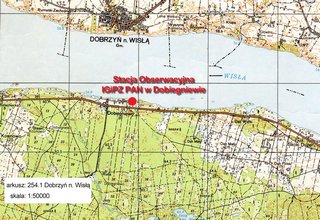
The station is located in the west of the Płock Basin on the left bank of the Włocławek reservoir. In physico-geographical respect, that basin is the southernmost mezoregion of the Toruń-Eberswald ice-marginal valley. The Płock Basin is an asymmetrical enlargement (12-18 km) of the Vistula River valley, extending between Płock and Włocławek. From the north and south, it is surrounded by young glacial moraine of Dobrzyn and Kujawy uplands. The northern, right-bank side of the valley undercut by the Vistula begins with a steep slope of moraine upland. It is circa 50m in height, being at between 10 and 50° angle of slope inclination. In the slope, there occurs a profile of Neogene and Quaternary sediments. The Miocene is represented by markedly disrupted a brown coal formation, and the Pliocene - by variegated Poznań clays. The Quaternary sediments are made up of two layers of glacial till separated by sandy-gravel series.
Complicated geological structure, hydro-geological conditions, lateral erosion of river before dam construction, and abrasion after construction of the Włocławek reservoir, all these factors played a decisive role in the intensive process of surface mass movements (downfalls, landslides, or landslips). It is the largest compact landslide area that can be found in the Polish Lowland. To the southward, the valley bottom raises gradually in the system of fluvial and fluvioglacial terraces. Surface terraces, in particular in the center of the pradolina, are diversified by various types of dune forms. In that part of the pradolina where dune-forming processes are most markedly visible, the denivelations exceed 30 m. An essential element of the relief of the valley bottom constitutes two paths of subglacial channels. Even though their course is, to a larger extent, masked by later formed dunes, after ultimate melting of dead ice blocks in the channel depressions lakes were formed. Because of their number (63 lakes), S. Lencewicz named that area the Gostynin Lakeland.
Due to highly permeable sandy-gravel rock material, there is a poorly developed hydrographic network. Surface run-off is shaped by the two river systems. These are composed of several kilometers long streams that drain the dune area and the Skrwa Lewa and Rakutówka rivers, of which the source region is located outside the bottom of the valley. In the Płock Basin, there prevail podzolic and rusty soils. Smaller areas are covered by brown soils as well as peaty and muck soils. Owing to poor soils and disadvantageous hydrological conditions, large areas are covered by forests (62%). Forest fresh sites constitute the dominant type of forest, diversified by stretches of dry, moist, and mixed forest, as well as by dry ground, riparian and ash-alder swamp forests.
The Włocławek reservoir formed in 1970 is the largest dam reservoir in terms of surface area (75 square kilometers) and the second one regarding cubic capacity (370 million cubic meters). The length of this water body is 57 km and its width ranges between 500 and 2500 m. It includes the former river bed along with low terrace levels. The average depth reaches up to 5.5 m, and the maximum one is 15 m. Mean annual fluctuations of water levels in the reservoir are about 1 m, but average daily fluctuations are about 6 cm. The reservoir is characterized by high flow-through. Theoretical water retention time at average runoff is 5 days. Its low useful storage, namely 13.5%, limits its retention function. Morphological characteristics of reservoir basin and the short time of water exchange influence the polymictic character of water masses mixing.

