Department of Geoecology
ON-LINE RESOURCES
 |
Jan Marek Matuszkiewicz
|
Theoretical and methodical basis
Geobotanical regionalization is a hierarchic division of the geographical space performing according to the specific rules by vegetation diversity. This geobotanical regional division of Poland is an original study and it supplements Author's previous proposal presented in:
- Matuszkiewicz J.M., 1993, Krajobrazy roślinne i regiony geobotaniczne Polski [Vegetation landscapes and geobotanical regions of Poland], Prace Geograficzne IGiPZ PAN, 158, 107 s.
The division of 1993 has also been presented in two cartographical publications:
- Matuszkiewicz J.M., 1994, 42.5. Krajobrazy roślinne i regiony geobotaniczne 1:2 500 000. 1. Krajobrazy roślinne, 2. Regiony geobotaniczne (in:) Atlas Rzeczypospolitej Polskiej, IGiPZ PAN, Główny Geodeta Kraju, Warszawa.
- Matuszkiewicz W., Faliński J.B., Kostrowicki A.S., Matuszkiewicz J.M., Olaczek R., Wojterski T., 1995, Potencjalna roślinność naturalna Polski. Mapa przeglądowa 1:300 000 [Potential natural vegetation of Poland. General map 1:300 000], IGiPZ PAN, Warszawa.
Detailed theoretical and methodical basis of the regionalization is presented in the first publication. It should be pointed out that general maps of potential natural vegetation were the most important source of knowledge on the diversity of geographical space and they were used to determine regions' division at a basic level. However, the classification of higher units was based on various criteria resulted from landscape, syntaxonomical and biogeographical characteristics.
Hierarchy of regional units
Geobotanical regionalization has a character of a hierarchic division and it includes the following classes of regions marking with specific codes:
- I - geobotanical divides (codes: A-I), partly divided into geobotanical subdivides (codes: E and E'), in the table classified into appropriate higher units - geobotanical provinces and alternatively geobotanical subprovinces,
- II - syntaxonomical regions (codes: e.g. A.1 or C.5), sometimes divided into syntaxonomical subregions (codes: e.g. A.5a),
- III - landscape regions (codes: e.g. A.3.1), divided into landscape subregions (codes: e.g. A.3.1.a).
In the presented regionalization, the territory of Poland is divided into:
- 4 geobotanical provinces (one of them is comprised of two geobotanical subprovinces),
- 9 geobotanical divides (one of them is comprised of two geobotanical subdivides),
- 34 syntaxonomical regions (nine of them are comprised of 2 to 4 syntaxonomical subregions),
- 187 landscape regions,
- 928 landscape subregions.
Remarks on the study form
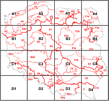
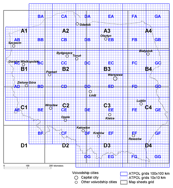
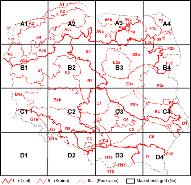
Geobotanical regional division of Poland is presented on 15 detailed charts, together with names of the most important towns and the ATPOL square grid. There are also printed codes of the basic regional units - landscape subregions. Additionally, to facilitate using of the detailed charts, there are presented 2 general charts with the division of syntaxonomical subregions and higher units, as well as the division of the map sheets and with the ATPOL square grid.
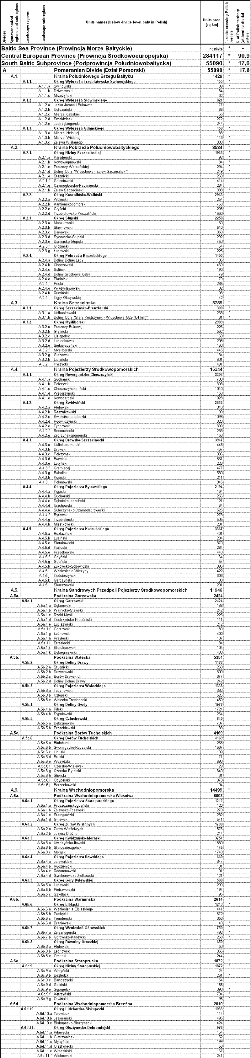
The hierarchic regional division is presented in the table. It contains: codes, names of regions (in Polish and partly in English) and data on the regions' size.
This study is compatible in the form with the map of potential natural vegetation of Poland [Jan Marek Matuszkiewicz, Potential natural vegetation of Poland, IGiPZ PAN, Warszawa, 2008].
Download
- Explanations (in polish and english) + point 2 [download pdf file, 4,2 MB].
- Pack of 15 raster maps of geobotanical regionalization (with settlements and ATPOL square grid) + general chart of geobotanical regionalization with the division into 16 sheets + general chart of map sheets and ATPOL square grid [download archive zip, 3,8 MB].
- List of geobotanical regions - the hierarchic regional division (codes, names of regions and data) [download Excel file].
General chart of geobotanical regionalization map sheets
List of geobotanical regions (fragment)
The map is protected by copyright of Jan Marek Matuszkiewicz. The reproduction and distribution of the map as a whole or in parts is only possible with the author's written consent. Without this permission, it is only allowed to copy single sheets of the map for scientific or educational purposes with the right quotation.
Webmaster: Jacek Wolski
Last update: 25.06.2012