GIS and Cartography Workgroup
Finished projects
GraphScape
Free software for landscape structure analysis and mobility modelling based on graph theory. ![]()
AVISO Geographic Information System
|
Mapping and geographic data management system, developed in IGSO and used in IGSO cartography projects. |
|
AIMS - AVISO Internet Map Server
The software for publishing true GIS maps on the internet, designed and developed IGSO. Drives IGSO Map Server with two mapping websites: Poland Topo Map on-line and Internet Atlas of Poland.
Digital Map of Poland
A complete set of topographic geo-referenced layers that support IGSO cartographic projects. The coverage at the scale of 1:200 000 encompasses the whole of Poland and adjacent parts of the neighboring countries.
Road Maps of Poland
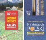
The maps were created for the Reader's Digest Polska publishing house. The map at a scale of 1:300,000 was included in the car atlas of the Roads of Europe, and the 1:200,000 scale was the core of the atlas On the roads of Poland. A universal guide for drivers and travelers.
Digital Atlas of Poland

The Digital Atlas of Poland, conceived in the years 1999-2000 was the first entirely digital publication of this kind being the work of cartography specialists. It was later superseded by the Internet Atlas of Poland.
Atlas of the Republic of Poland

The Atlas of the Republic of Poland is most extensive, country-wide collection of cartographic work, contracted by the Surveyor General of Poland. The former Department of Cartography and Geographic Information Systems prepared the General Concept, carried out all cartographic editing and most of the technical editing, as well as co-ordination of contributions by 164 authors. The effect sums up to 157 sheets, containing hundreds of maps.