Department of Geoecology
ON-LINE RESOURCES
 |
 |
Jan Marek Matuszkiewicz
|
Jan Marek Matuszkiewicz, Jacek Wolski
|
Potential natural vegetation as the subject of cartographic presentation
The idea of potential natural vegetation has been present in geobotany since the 1950s and is understood as the hypothetical state that could be achieved through natural succession of vegetation if human impacts were eliminated and the region-specific vegetation could make full use of the habitat.
Potential natural vegetation is described in terms of typological units of natural plant communities which may occur in a defined region. "Plant associations" are typological units used most frequently in cartographic presentation. The Latin names of communities used to determine the legend units correspond to the final development stages of plant communities known from research in a given region, possible to be achieved in a given habitat through primary succession or, more often, secondary succession.
Basic map
The basic map was created as a result of many years of work by a team of 29 Polish geobotanists, based on field mapping, carried out mainly in the 1970s. The entire work at the stage of field mapping and initial aggregation of map fragments was supervised by Władysław Matuszkiewicz.
The final printing of the merged map in the scale of 1:300 000 (12 sheets, each with individual supplementary elements) was made at the Military Cartographic Institute in 1994-1995 as part of a project carried out at the Institute of Geography and Spatial Organization, Polish Academy of Sciences. The project manager was Jan Marek Matuszkiewicz, who had the right to disseminate and use the basic map.
The recommended way to cite the basic map: Matuszkiewicz W., Faliński J.B., Kostrowicki A.S., Matuszkiewicz J.M., Olaczek R., Wojterski T., 1995, Potential natural vegetation of Poland. General map 1:300 000, IGiPZ PAN, Warszawa.
Raster map
The raster map of potential natural vegetation is a derivative version of the printed basic map. In the first step, the content of all 12 sheets (without the background elements) was vectorized, obtaining two continuous layers for the whole of Poland. In the next stage, digital maps were used to generate a cartographic image of the diversity of potential natural vegetation in the form of raster files.
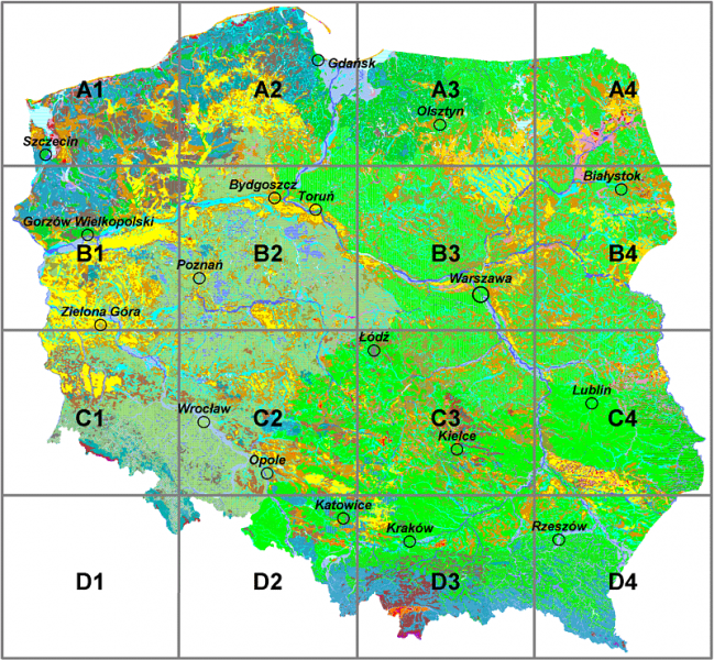
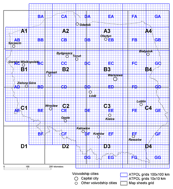
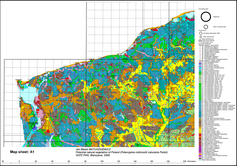
For the needs of the presentation, the projection was changed, as well as a new color legend and a new 16 sheets division were developed. For better orientation, 2080 localities (5 categories) and a grid of the ATPOL system were marked on the maps.
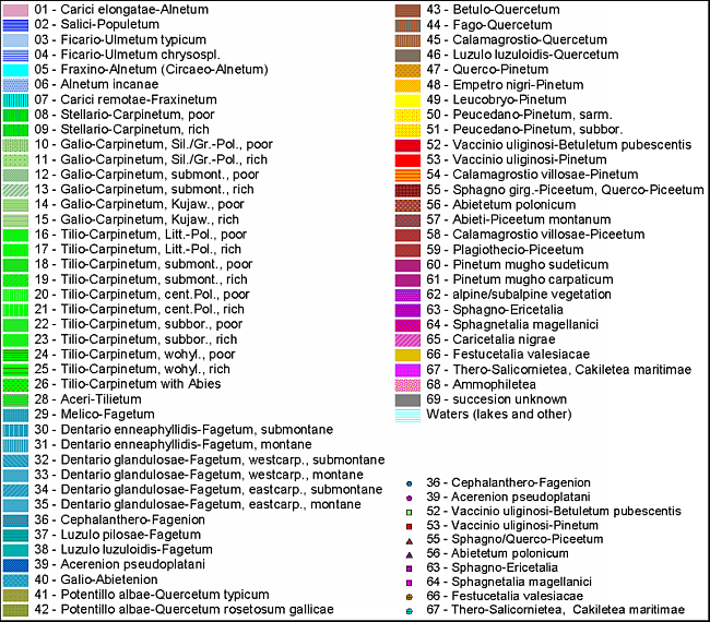
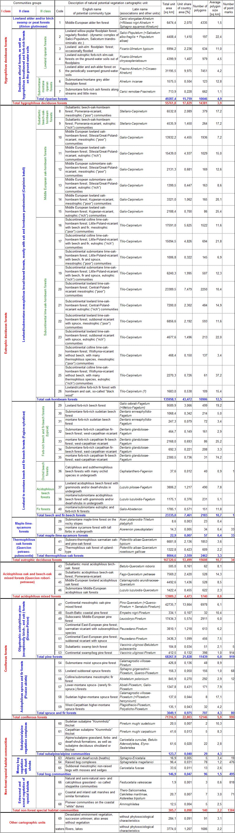
The map legend includes 69 cartographic units of potential natural vegetation (+ water), of which 10 are also presented as point marks. Description of the units and numerical data are included in a separate table.
The recommended way to cite the raster map: Matuszkiewicz J.M., 2008, Potential natural vegetation of Poland, IGiPZ PAN, Warszawa (https://www.igipz.pan.pl/potential-vegetation-dge.html)
Vector map
As part of the cooperation of Jan Marek Matuszkiewicz with the GIS and Cartography Workgroup in IGiPZ PAN, another derivative product was developed in 2023 - a vector map. The basis for the work was the digital version from over 25 years ago. A multi-stage topology correction was performed with the use of analytical geometry tools (ArcGIS, QGIS). After that, the total number of polygons is 45,792, and point marks - 2,417.
The vector map’s attribute table contains the following information:
- code of the cartographic unit of the potential natural vegetation community,
- area of the polygon in km2,
- full name of the cartographic unit in Polish, including the basic name of the association and possibly lower-level typological units, such as varieties, forms and series (e.g. subcontinental submontane lime-oak-hornbeam forest, Little-Poland-vicariant, mesotrophic ("poor") communities),
- English equivalent of the unit name (translation from Polish),
- syntaxonomic characteristics (in Latin),
- hierarchical group of communities of the 1st, 2nd and 3rd order (e.g. hygrophilous deciduous forests => deciduous alluvial forests => lowland riparian forests).
Vector layers in the 1992 coordinate system are distributed in the .shp format. The numerical data characterizing the cartographic units of potential natural vegetation have been updated. The new tabular summary from June 2023 is a uniform for raster (2008) and vector (2023) maps.
The recommended way to cite the vector map: Matuszkiewicz J.M., Wolski J., 2023, Potential natural vegetation of Poland (vector version), IGiPZ PAN, Warszawa.
Download files
- Explanations [pdf file].
Raster map
- Set of 15 raster maps of potential natural vegetation with legend (with settlements and ATPOL square grid) + general chart of potential natural vegetation (without borders) with the division into 16 sheets + general chart of map sheets and ATPOL square grid [archive zip].
- Set of 15 raster maps of potential natural vegetation with legend (without settlements and ATPOL square grid) [archive zip].
- Spatial characteristics of the legend units of the potential natural vegetation map of Poland [Excel file].
Vector map
- Two vector layers (.shp) with polygon subdivisions (prn_area) and point marks (prn_points) [archive zip].
Index of potential natural vegetation map sheets (raster version)
ATPOL system (raster version)
Potential natural vegetation map of Poland - example sheet (raster version)
Legend of potential natural vegetation map of Poland (raster version)
Spatial characteristics of potential natural vegetation map of Poland legend units (June 2023 update)
The map is protected by copyright of Jan Marek Matuszkiewicz. The reproduction and distribution of the map as a whole or in parts is only possible with the author's written consent. Without this permission, it is only allowed to copy single sheets of the raster map or parts of vector map for scientific or educational purposes with the right citation.
Webmaster: Jacek Wolski
Translated by Anna Kowalska
Last update: 30.06.2023